

All data in the same 3D environment
In a project, it is often difficult to know which geotechnical surveys have been carried out and where they are located. The bigger the project, the harder it is. When an organisation that manages geotechnical data, such as the Transport Agency or a municipality, is planning a new project, it is often difficult to know which surveys have been previously executed at different locations.
Previously, it has been difficult to handle data and and transfer information manually, for example to Excel, to maximize the benefit of the entire data volume. Now we have access to all stored geotechnical data in a single database and can easily communicate it.
GeoBIM functions
The following features are offered through the GeoBIM Portal, so please do not hesitate to contact us for more information.
Database
A scalable database in the cloud that contains all of your data.
Webmap
A live map that gives you a good overview of and access to your data.
3D-model
A 3D-model that shows your data in its spatial context, as well as the ability to add additional information.
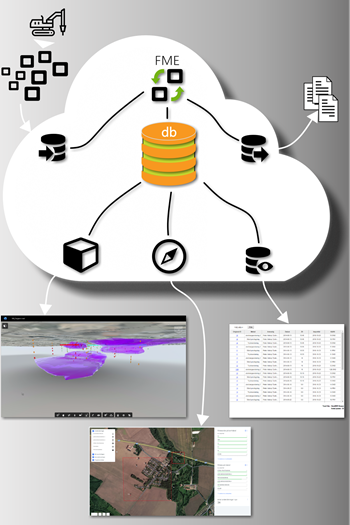
Webviewer
The webviewer gives you the opportunity to review the data in the smallest detail.
Services
Examples of services we offer: field investigations, laboratory tests, design, and GeoBIM coordination.